10 October 2026
Mostly cloudy. A few showers about the Sounds and inland ranges, possibly heavy from afternoon. Northeasterlies, strong at times about the Kaikoura Coast from afternoon.
Loading outdoor place details…
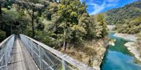
Pelorus Bridge Scenic Reserve
The wheelchair-friendly Circle Walk alongside Te Hoiere/Pelorus River continues as the Circle Loop Track. This track is part of Te Araroa Trail.
Distance
2 km
Walking time
45 min
Difficulty
Easiest
Dogs
Not allowed
Wheelchair access
Friendly
Current status
No active alerts found. Conditions can still change, so check again before leaving.
Weather outlook
Issued 10 Oct 2026, 4:55 pm
10 October 2026
Mostly cloudy. A few showers about the Sounds and inland ranges, possibly heavy from afternoon. Northeasterlies, strong at times about the Kaikoura Coast from afternoon.
11 October 2026
Cloudy with showers, mainly about the Sounds and inland ranges, clearing and becoming mainly fine late afternoon. Northwesterlies but northeasterlies about Kaikoura Coast, strong at times, easing everywhere in the evening.
12 October 2026
Fine. Northerlies developing in the morning.
13 October 2026
Mostly cloudy with isolated showers, clearing to fine in the afternoon. Northwesterlies developing in the morning.
14 October 2026
Mostly cloudy with isolated showers, turning to rain in the afternoon. Northwesterlies, dying out in the evening.
Regional guidance only; elevation and terrain can produce different conditions.
Explore the area
Explore the track route and surrounding area before you set out.
This track is part of Te Araroa Trail and connects to Daltons Track, which is also part of the trail. The Circle Loop Track begins as the easy Circle Walk alongside Te Hoiere/Pelorus River. The wheelchair-standard path overlooks the river and goes as far as a suspension bridge. The bridge crosses the Rai River just before it feeds into the Te Hoiere/Pelorus River. Beyond the bridge the track becomes uneven with steps and tree roots as it makes a loop through a pocket of forest. It has short stretches with steps and moderate gradients but is otherwise flat. For part of its length the track follows the river, providing good views of its junction with the Rai River.
Always carry warm, waterproof clothes, especially on longer walks. Take care when the tracks are wet or the river flooded.
Situated on the banks of the Te Hoiere/Pelorus River amongst towering kahikatea, beech and rimu trees, Pelorus Bridge Campground is very popular in summer, and advanced bookings are advised.
The reserve is located midway between Blenheim and Nelson on SH6, 18 km west of Havelock. Use this location in Google Maps to find your way there.
We encourage you to continue gaining the skills and knowledge required for a safe trip. The NZ Mountain Safety Council has lots of free resources and information you can use. These can be accessed via www.mountainsafety.org.nz . Level up in your outdoor knowledge with these interactive online learning tools: Trip Planning Tramping / field Skills Basic Navigation River Safety Additionally, check out the range of helpful videos available from the NZ Mountain Safety Council YouTube channel .
No dogs.
Track information, access and weather can change. Confirm current alerts and land-manager information close to departure, tell someone your plans, and carry equipment appropriate for the route and conditions.