11 October 2026
Partly cloudy with showers about the ranges. Northerlies, turning westerly early afternoon, dying out early evening.
Loading outdoor place details…
Paparoa National Park
The Paparoa Track crosses the Paparoa Range. It takes you through alpine tops, limestone karst landscapes, thriving rainforests and provides breath-taking views.
Distance
55 km
Walking time
3 days one way
Difficulty
Intermediate
Dogs
Not allowed
Wheelchair access
Not marked friendly
Current status
No active alerts found. Conditions can still change, so check again before leaving.
Weather outlook
Issued 11 Oct 2026, 4:35 pm
11 October 2026
Partly cloudy with showers about the ranges. Northerlies, turning westerly early afternoon, dying out early evening.
12 October 2026
Areas of morning and evening cloud, otherwise fine. Westerlies developing for a time in the afternoon.
13 October 2026
Occasional rain from morning. Northerlies developing in the morning.
14 October 2026
Rain, with heavy falls. Northerlies, turning westerly in the afternoon.
15 October 2026
Showers, easing in the evening. Light winds.
Regional guidance only; elevation and terrain can produce different conditions.
Explore the area
Explore the track route and surrounding area before you set out.
For the first hour of the track, you’ll pass through mixed podocarp and beech forest and cross a wire suspension bridge over the Smoke-ho Creek. The track then zig-zags up the dividing ridge between Blackball Creek and Roaring Meg catchments for the next hour until you reach the turn-off to the Battery Track. From there the track climbs more steeply into subalpine forest leading towards Ces Clark Hut. You’ll pass the historic Croesus Top Hut just before reaching Ces Clark Hut. Croesus Top Hut is kept for historic purposes – you cannot stay at Croesus Top Hut. However, in an emergency, you can use it for shelter. Ces Clark Hut is on the edge of the bushline, set among low alpine scrub and with spectacular views. On a fine day you will be rewarded with views of Lake Brunner, the main divide, and down to Aoraki Mount Cook.
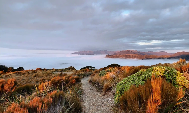
Beyond Ces Clark Hut you pass through alpine scrub and tussock with expansive views of Grey River/Māwheranui and Tasman Sea. The track follows the ridge of the main Paparoa Range through open alpine vegetation above the Roaring Meg and Moonlight Creek catchments, with views of Aoraki/Mt Cook on a clear day. Moonlight Tops Hut has panoramic views across the Punakaiki River headwaters around to the escarpment, Pike Stream and Paparoa National Park.
Paparoa Track winds along the top of the escarpment, with steep cliffs and stunning views. There is an emergency shelter on the northern end of the escarpment. About half-way to Pororari Hut, you descend from the escarpment through ancient podocarp forest. The track then follows the ridge above Tindale Creek to Pororari Hut. Keep an eye out for the Lone Hand, a gnarled outcrop of rock on the north side of the Pororari River.
The track descends into the upper Pororari River valley and follows the river. In some places it follows an old track which was built c1912–1914 to establish a settlement in the valley. The track sidles along a spectacular gorge and descends through beech forest interspersed with northern rātā. At the junction of the Inland Pack Track and the Paparoa Track, trampers and mountain bikers diverge. Walkers take the Pororari River Track through the Pororari River Gorge, passing through lush rainforest with glades of nikau palms. As an alternative, trampers can turn south at the junction with the Inland Pack Track, finishing at Waikori Road.
There are three Great Walk huts on the Paparoa Track: Ces Clark Hut, Moonlight Tops Hut and Pororari Hut. Bookings are required. Huts have bunks, mattresses, heating, gas cooktops, toilets, and a water supply. For a 3-day trip, stay at Moonlight Tops and Pororari Huts. It's not feasible to stay at Ces Clark Hut and Pororari Hut – it's 28.8 km and a 10 hr walk between these two huts. For a 4-day trip, stay at Ces Clark, Moonlight Tops and Pororari Huts. Alternatively, for a 2- to 3-day trip to Pororari Hut, see Paparoa Track: Pororari Hut Track . There are no campsites on the track.
The nearest towns are Blackball, Greymouth and Punakaiki. The track can be accessed by road at: Smoke-ho car park at the end of Blackball Road, 8 km north of Blackball. Pororari River Track carpark on SH 6, 1.2 km north of Pancake Rocks at Punakaiki Waikori Road carpark on SH 6, 2.4 km south of Pancake Rocks at Punakaiki Links above take you to Google Maps to help you find your way there.
We encourage you to continue gaining the skills and knowledge required for a safe trip. The NZ Mountain Safety Council has lots of free resources and information you can use. These can be accessed via www.mountainsafety.org.nz . We recommend trying these online learning tools: Trip Planning Tramping / field Skills Basic Navigation River Safety Additionally, check out the range of helpful videos available from the NZ Mountain Safety Council YouTube channel .
Weather in Paparoa National Park is changeable with annual rainfall averaging around 6,000 mm (235 inches). Heavy rain, snow, ice, fog and strong winds are possible at all times of the year, especially on the exposed sections of the track. You must be well equipped and prepared for all weather conditions and carry warm and waterproof clothing. If the weather becomes severe, stay put in a hut or turn back until conditions improve. Some sections of track in the Pororari Valley may become impassable during times of very heavy rainfall. There is also a risk of landslides. There is danger of treefall in extreme wind events. Do not attempt to travel between Pororari Hut and the carparks in Punakaiki if these conditions occur. Take shelter in Pororari Hut and wait until conditions improve. If you are hiking the track in winter, check for snow and ice conditions before you leave and allow extra time. If in doubt, consider changing your trip to another day.
No dogs.
Track information, access and weather can change. Confirm current alerts and land-manager information close to departure, tell someone your plans, and carry equipment appropriate for the route and conditions.