10 October 2026
Partly cloudy with the odd shower, then rain developing in the evening, possibly heavy. Northeasterlies developing in the morning.
Loading outdoor place details…
Whangārei
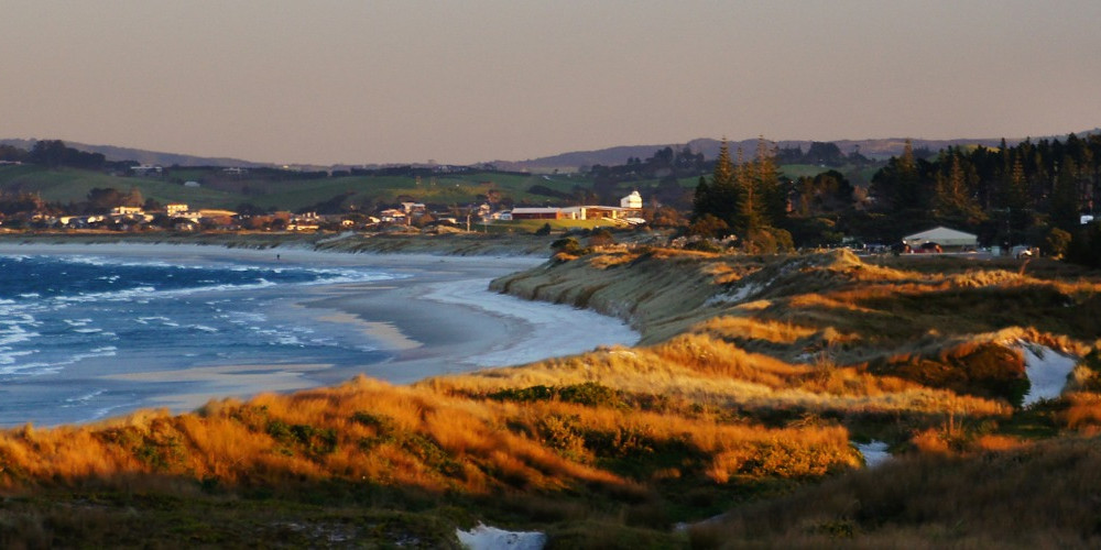
Te Araroa section: Bream Bay stretches along Northland’s east coast and includes many sparkling beaches such as the Ruakaka, Waipu and Waipu Cove. The bay has great swimming, fishing, surfing, walking and sunbathing. For bookable DOC facilities (such as Uretiti Beach Campsite) you need to make sure that your Trail Pass and DOC Bookings account are linked – so that when you make the booking, the DOC system knows you have a Trail Pass and the discount is applied. When you registered we provided you with instructions of how to do this, to make sure you didn’t experience delays in accessing the discount on bookable facilities. If you haven’t created your DOC bookings account you must do so now. Once you have made an account, email booking@doc.govt.nz with a copy of your Trail Pass and they will connect the two. This may take 3-5 days.
Distance
24.7 km
Walking time
7 hours
Difficulty
Easy
Dogs
Not allowed
Wheelchair access
Not marked friendly
Current status
No active alerts found. Conditions can still change, so check again before leaving.
Weather outlook
Issued 10 Oct 2026, 10:55 am
10 October 2026
Partly cloudy with the odd shower, then rain developing in the evening, possibly heavy. Northeasterlies developing in the morning.
11 October 2026
Occasional rain, clearing for a time in the morning and afternoon. Northwesterlies.
12 October 2026
Cloud clearing and becoming fine in the morning. Northerlies, turning westerly before dawn.
13 October 2026
Partly cloudy, with showers in the afternoon. Westerlies developing in the morning.
14 October 2026
Isolated showers, with increasing cloudy periods. Northwesterlies.
Regional guidance only; elevation and terrain can produce different conditions.
Explore the area
Explore the track route and surrounding area before you set out.
Bream Bay Walk - 21km / 4 hours From Marsden Point, walk south along the beach (low tide is best). Tide information for Bream Bay If you want a respite from an easterly wind, there is a 3.5km inland DOC track which starts beyond the oil refinery (end of Mair Road) & follows a pipeline to end behind the Mighty River Power station at Ruakākā (end of Sime Road). 9km down the beach is the Ruakākā River mouth, which can be hazardous to cross on foot and should only be done at low tide. Do not attempt to cross the river at the beach, instead turn west and walk 400m along the estuary shoreline. This is a wildlife sanctuary with many migrant and wading birds, so please do not walk inside the fenced-off nesting areas, and please keep moving to limit disturbances to the birds during nest season. Opposite the rock/concrete wall (on the south side) is the best place to cross. (For assistance, you can contact Simon Ellison, who can help with a kayak crossing. Please arrange a day in advance, and a koha — donation — is appreciated. Phone: 021 233 6748) Another 6km brings you to a sign on the sandhills for a track leaving the beach and going over the dunes to Tip Road. From the beach, follow Tip Road west. Turn south onto Uretiti Road, and south again onto Nova Scotia Drive. This will take into the heart of Waipū. Waipu to Cullen Road - 6.4km To leave Waipū township, take Cove Road to the southeast and follow it 6.5km to the junction with Cullen Road. An off-road trail is under construction with 5km now completed and available to ensure safe walking along this narrow high-speed local road. Known as the Waipu Cycleway and Walkway, the completed sections are: Cove Road, from Waipu Village to Riverview Place. This section provides welcome shade during summer months with seating available. Cove Road, from McLean Road to Cullen Road. There are attractive spots to rest with views of Bream Bay, offshore islands and local wetland restoration planting. Cullen Road to Waipu Cove For those staying at the Waipu Camp overnight or replenishing supplies at the Waipu Store — this section provides a flat, easy, safe walk
Potential Hazards Vehicles on road or track Tides, waves & rivers - safer at low tide River crossings - Never cross flooded rivers Track exposed to sun, wind or cold Note: For hikers heading north from Marsden Point to Reotahi, the marina at Marsden Cove is a good point to organise a trip across the harbour.
Northern Start: Marsden Pt (beach) Southern End; Corner Cove and Cullen Roads, Waipū Ruakaka Marsden flyer - Ruakaka Shuttle Services - P: 09 432 8158 A 2 B Auckland Airport Direct Shuttle - (to/from Whangarei, Marsden Point, Ruakaka - P: 09 459 5221 or 027 273 7307 Detour option available The Marsden Point Oil Refinery Visitors Centre, Marsden Pt, Ruakaka - P: 09 432 8194 The display includes a 130sqm working scale model and an impressive 20 minute light and sound show. Photographs, records and models show the huge pipeline that stretches from Marsden Point all the way to Wiri in South Auckland. Detour off the beach to Ruakaka Town Centre, Marsden Point Rd.For more information log onto - Ruakaka Visitor Information Waipu InterCity from Auckland - P: 09 583 5780 - E: info@intercity.co.nz Northliner Express Coach Service - P: 09 307 5873
Before starting Te Araroa either as a through-walker of the whole country or a section walker, please register on Te Araroa website . Please also visit the website or download the app for detailed maps, trail alerts and other relevant information. This track is part of the Herenga ā Nuku Aotearoa track database. Herenga ā Nuku has maps and advice about public access to the outdoors . We encourage you to continue gaining the skills and knowledge required for a safe trip. The NZ Mountain Safety Council has lots of free resources and information you can use. These can be accessed via www.mountainsafety.org.nz . We recommend trying these online learning tools: Trip Planning Tramping/field Skills Basic Navigation River Safety Additionally, check out the range of helpful videos available from the NZ Mountain Safety Council YouTube channel .
Potential HazardsVehicles on road or track Tides, waves & rivers - safer at low tide River crossings - Never cross flooded rivers Track exposed to sun, wind or cold Note: For hikers heading north from Marsden Point to Reotahi, the marina at Marsden Cove is a good point to organise a trip across the harbour.
Track information, access and weather can change. Confirm current alerts and land-manager information close to departure, tell someone your plans, and carry equipment appropriate for the route and conditions.