10 October 2026
Cloudy with showers, possibly heavy and thundery about the ranges. Northeasterlies.
Loading outdoor place details…
Greymouth area
This Nelson Creek walk takes you through forest to a view of bush clad valleys, crossing historic tail and water races.
Distance
2.6 km
Walking time
1 hr return to lookout, 1 hr 30 min return to Prices Creek Road
Difficulty
Easy
Dogs
Not allowed
Wheelchair access
Not marked friendly
Current status
No active alerts found. Conditions can still change, so check again before leaving.
Weather outlook
Issued 10 Oct 2026, 4:55 pm
10 October 2026
Cloudy with showers, possibly heavy and thundery about the ranges. Northeasterlies.
11 October 2026
Showers, possibly heavy, retreating to the ranges in the afternoon, clearing in the evening. Northerlies, easing in the afternoon.
12 October 2026
Fine. Westerlies developing for a time in the afternoon.
13 October 2026
Occasional rain. Light winds.
14 October 2026
Rain with heavy falls easing to a few showers in the afternoon. Northwesterlies, dying out in the morning.
Regional guidance only; elevation and terrain can produce different conditions.
Explore the area
Explore the track route and surrounding area before you set out.
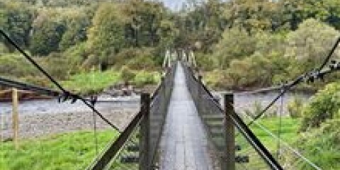
This is a moderately difficult track with rough, steep and overgrown sections. To start the walk, go through an old hand picked tunnel and cross the Nelson Creek suspension bridge. It climbs steadily to a mossy knoll lookout point where you get a view into the bush clad valleys on either side of the ridge. On the way to the lookout point the track crosses a couple of deep tail races and a large water race as well as passing through regenerating beech. As the track climbs the forest is mostly podocarp/hardwood with rimu, miro, rātā, quintinia and kāmahi being the most common species. After the lookout point, the track levels out and eventually links with Prices Creek Road - a forestry road. Stay on the track as shafts and tunnels are scattered throughout the area. Return by the same route. Use this location on Google Maps to help find your way there.
No dogs.
Track information, access and weather can change. Confirm current alerts and land-manager information close to departure, tell someone your plans, and carry equipment appropriate for the route and conditions.