11 October 2026
Fine apart from some evening cloud. Northwesterlies, turning southwesterly in the afternoon, dying out early evening.
Loading outdoor place details…
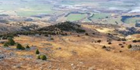
Pisa Conservation Area
Access the Locharburn Scenic Reserve and Pisa Conservation Area via a steep, direct hike.
Distance
13.36 km
Walking time
4-6 hr return
Difficulty
Intermediate
Dogs
Not allowed
Wheelchair access
Not marked friendly
Current status
No active alerts found. Conditions can still change, so check again before leaving.
Weather outlook
Issued 11 Oct 2026, 4:35 pm
11 October 2026
Fine apart from some evening cloud. Northwesterlies, turning southwesterly in the afternoon, dying out early evening.
12 October 2026
Fine, but morning fog possible in sheltered valleys. Northwesterlies.
13 October 2026
Rain in the afternoon and evening, otherwise isolated showers. Northwesterlies, dying out at night.
14 October 2026
Rain, easing to a few showers north of Alexandra in the afternoon. Light winds.
15 October 2026
Showers easing in the afternoon. Southerlies developing in the morning.
Regional guidance only; elevation and terrain can produce different conditions.
Explore the area
Explore the track route and surrounding area before you set out.
The Locharburn Track is a steep climb to the Locharburn Scenic Reserve and Pisa Range. Starting from the Luggate-Cromwell Road (SH6), the track heads immediately uphill, immersing you instantly into how steep this track is for much of the first half of the climb. There isn't much of a track to follow, so follow along close to the fenceline which leads into the Lochaburn Scenic Reserve. You'll meet another fence with a stile to help you cross, and by continuing to follow the fenceline uphill, you will eventually meet the farm road. Please note that this section is on private land, so please keep to the fencline and farm road, following this and the signs until you reach the conservation land which you'll enter just below the 1200m contour. Continue to follow the farm road to reach Pisa Range Ridge Track. You can also use this trail to connect with the Pisa Range Ridge Track to access Lake McKay, Mt Pisa and other destinations in the Pisa Conservation Area.
Weather: In summer, very hot and dry conditions are common and there is no shade. Taking plenty of drinking water and wearing sun protection is essential. In winter, mountaineering experience and equipment is required along with knowledge of avalanche conditions. Check the New Zealand Avalanche Advisory for Queenstown before you go as this track crosses known avalanche paths. Private property: The track crosses private land. Respect the landowner's livestock and property by staying on the marked track until you reach the conservation area, leave gates as you find them and use stiles where provided. Livestock can be unpredictable – keep your distance at all times or go around if necessary. Dogs: Dogs are allowed in the Pisa Conservation Area, but access is restricted to the Rock Peak Track at the southern end of the range. All other entry points require landowner permission to enter with a dog. Contact the landowner to seek permission .
Camping can happen anywhere within the conservation area boundary, but is prohibited on private land. Robrosa Hut is a private hut north of Mt Pisa which sleeps four comfortably, or six at a squeeze. Contact the owner to book . Kirtle Burn Hut is a DOC managed hut available on the western slopes of Mount Pisa which has seven bunks.
From Wānaka, drive approximately 30 km south on SH6. There is no carpark, and the trailhead signs are not obvious from the road, but there is a short siding where you may park. Once you've found a safe place to park you'll find small signs at the trailhead indicating the route. Use this location in Google Maps to find your way there.
We encourage you to continue gaining the skills and knowledge required for a safe trip. The NZ Mountain Safety Council has lots of free resources and information you can use. These can be accessed via www.mountainsafety.org.nz . Level up in your outdoor knowledge with these interactive online learning tools: Trip Planning Tramping / field Skills Basic Navigation River Safety Additionally, check out the range of helpful videos available from the NZ Mountain Safety Council YouTube channel .
No dogs.
Track information, access and weather can change. Confirm current alerts and land-manager information close to departure, tell someone your plans, and carry equipment appropriate for the route and conditions.