10 October 2026
Cloud about the tops, then a few showers developing in the afternoon.
Loading outdoor place details…
Tongariro National Park
Explore the volcanic heart of Tongariro National Park, a landscape of stark glacial contrasts and alpine views. From May to late October, conditions can be challenging – only go if you have the skills.
Distance
35.5 km
Walking time
2-4 days
Difficulty
Intermediate, Advanced, Expert
Dogs
Not allowed
Wheelchair access
Not marked friendly
Current status
Weather outlook
Issued 9 Oct 2026, 9:24 pm
10 October 2026
Cloud about the tops, then a few showers developing in the afternoon.
11 October 2026
Showers, some heavy with snow to 2100 metres, becoming isolated in the afternoon but remaining cloudy.
12 October 2026
A few showers.
13 October 2026
Showers easing.
14 October 2026
Showers developing, some heavy.
Regional guidance only; elevation and terrain can produce different conditions.
Explore the area
Explore the track route and surrounding area before you set out.
Begin 100 metres below the Whakapapa Visitor Centre at Ngauruhoe Place and along the lower Taranaki Falls track. After about 20 minutes the Mangatepopo track branches off from the Taranaki Falls track. Heavily eroded in places, the track crosses many stream beds. Ahead and to the right is Pukekaikiore, thought to be one of the older vents of the Tongariro complex. To the left is Pukeonake, a low scoria cone. Both Pukekaikiore and Pukeonake witnessed the last ice age when glaciers from Tongariro carved down through Mangatepopo Valley. The giant cone of Ngauruhoe and the flatter form of Tongariro are visible ahead. Ngauruhoe is a younger ‘parasitic’ cone on the side of Tongariro. For the last hour the track skirts around Pukekaikiore until it reaches the Mangatepopo Valley track. The Mangatepopo Hut is five minutes off of the main track.
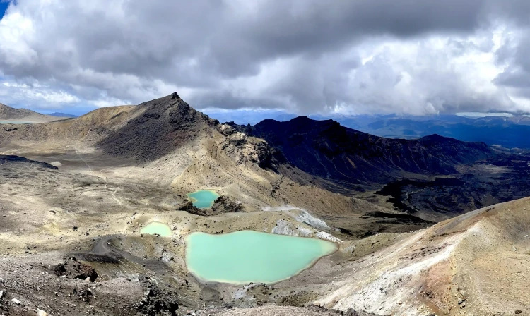
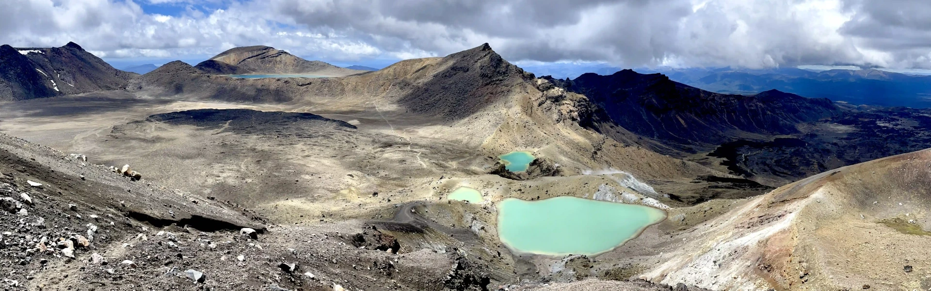
The track follows Mangatepopo stream up the valley, climbing over a succession of old lava flows from Ngauruhoe. A five minute detour at the head of the valley leads to the cold Soda Springs and waterfall, which emerge beneath an old lava flow. In spring and summer moisture loving plants such as white foxgloves and yellow buttercups thrive in the area. The steep climb required to reach the Mangatepopo Saddle rewards climbers views of the valley and if clear, Mt Taranaki to the west. From the saddle the track crosses South Crater, not a true crater but a drainage basin between the surrounding volcanic landforms. Ahead more recent lava flows can be seen spilling over from Red Crater. The climb up to Red Crater offers splendid views of Oturere Valley and Kaimanawa Ranges to the east. The main track continues on past the rim of Red Crater itself. The spectacular formation on the far side of the crater is a dike, an old magma feeding pipe to the vent of the volcano. Harder than the ash and scoria around it erosion has left it exposed on the side of the crater. A loose, rocky ridge leads down to the spectacular Emerald Lakes, which fill old explosion pits. Their brilliant colouring is caused by minerals washed down from the thermal area of Red Crater. The best way to descend this tricky section is to sink your heels into the scree, and 'jog' directly down in a straight line. Watch the Tongariro Alpine Crossing video (above) for a visual description. To continue to Oturere Hut, turn right at the track junction below Emerald Lakes. This track descends into the Oturere Valley with views of the valley, the Kaimanawa Ranges and the Rangipo Desert. The track weaves through an endless variety of unusual, jagged lava forms from early eruptions from Red Crater which filled Oturere Valley. After about 1.5 hours, you'll arrive at Oturere Hut, which is nestled on the eastern edge of these flows. There is a pretty waterfall over the ridge from the hut.
After leaving Oturere Hut the track undulates over a number of stream valleys and open gravel fields. Plant life here has been constantly repressed by volcanic eruptions, altitude and climate. Loose gravel means that recolonisation by plants is a slow process on the open and bare countryside. The track gradually sidles around the foot hills of Ngauruhoe descending into a valley and crossing one of the branches of the Waihohonu Stream. Continue through a beech clad valley before climbing towards the ridge top. Waihohonu Hut is in the next valley.
The track follows the Waihohonu stream and gradually climbs to Tama Saddle. This area can be windy as it sits between the mountains. From the saddle there is a very worthwhile side trip to the striking Tama Lakes, two infilled explosion craters. The lower lake is only 10 minutes from the junction, while the upper lake is up a steep ridge, taking 1 hour 30 minutes return. Whakapapa Village is about two hours from the Tama Lakes junction. After the first hour the track meets the Taranaki Falls loop walk, one of the best short walks in the Park. There are two options to return to the village, both take about an hour. To view the waterfall, follow the lower section of the track down the steps to its base, then follow the Wairere stream through beautiful mountain beech forest back to the village. Alternatively take the upper section of track through open tussock and shrubland back to the village.
Environmental hazards Most of the track is on rugged and exposed alpine terrain, although there are sections of formed track/boardwalk. There are only two sections of forest - near Whakapapa Village, and near Waihohonu Hut. The lowest altitude of the track is 1120 m, and the highest (at Red Crater) is 1886 m. The weather can change suddenly - from warm and sunny to cold, wet and windy. Most streams are bridged and there are no large river crossings, but heavy rain could cause flooded streams to become difficult to cross safely. Be prepared to wait for water levels to drop. Major hazards are generally managed on the track during the summer (October to April), and in winter the main hazard is snow/ice on the track. We recommend that you treat stream water to guard against risk of infection from giardia and other bugs. Do not take water from the lakes. Volcanic activity The Tongariro Northern Circuit passes through volcanic hazard zones and regularly experiences geothermal activity – even when the track is open, volcanic risk is present. Steam vents, especially near Emerald Lakes, should not be approached. The steam is very hot, the ground can be unstable and severe burns are possible. Always stay on the marked track to avoid injury. Parking The main parking area is at Whakapapa Village, where the Circuit begins and ends. Parking is free and generally safe. Winter conditions During winter months snow and ice can cover all or parts of the track, and avalanche risk may apply. Walking and navigation can become more difficult. Alpine experience and equipment is normally required during this period. Bring crampons and ice axe, avalanche transceiver, shovel and probe.
Tongariro Northern Circuit starts and ends in Whakapapa Village. The track can also be accessed from parking areas at: Mangatepopo Road end, off SH 47. Note, there is a 4-hour parking restriction at the Mangatepopo road end throughout the Great Walk season. Visit the Tongariro National Park Visitor Centre for a free parking permit or have your booking ticket available for the traffic management team to sight. Waihohonu track access point off the Desert Road (SH1), 35km south of Turangi. Use this location in Google Maps to find your way there.
We encourage you to continue gaining the skills and knowledge required for a safe trip. The NZ Mountain Safety Council has lots of free resources and information you can use. These can be accessed via www.mountainsafety.org.nz . We recommend trying these online learning tools: Trip Planning Tramping / field Skills Basic Navigation Additionally, check out the range of helpful videos available from the NZ Mountain Safety Council YouTube channel .
The track is in an alpine environment with changeable weather conditions at all times of year. Alpine conditions such as strong winds, cold temperatures and possible snow should be factored into planning. Cold temperatures (especially near the top) are still likely in the warmer months. A fine summers day has the possibility of afternoon convection causing thunderstorms.
No dogs.
Track information, access and weather can change. Confirm current alerts and land-manager information close to departure, tell someone your plans, and carry equipment appropriate for the route and conditions.